Vehicle-Borne Multi-Sensor Temporal-Spatial Pose Globalization via Cross-Domain Data Association
摘要
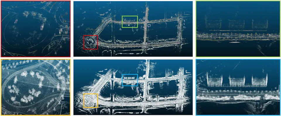
Large-scale urban scene 3D mapping has urgent demands and wide applications in many areas, where sensor pose globalization remains its fundamental problem and crit ical step. As the street-view images and vehicle-borne Light Detection And Ranging (LiDAR) points contain complementary advantages in urban scene 3D mapping, it is desirable to make the most of both to facilitate this task. Most existing methods make strong assumptions of strict synchronization, and even further, exact calibration between the vehicle-borne cameras and LiDARs, which are hard to guarantee in practice. To deal with this, we propose a novel pipeline for vehicle-borne camera and LiDAR temporal and spatial pose globalization with the guidance of Global Navigation Satellite System/Inertial Measurement Unit (GNSS/IMU), where both of the assumptions on strict synchronization and exact calibration are loosened. Specifically, the global poses of both cameras and LiDARs are first initialized by leveraging GNSS/IMU signals and multi sensor pre-calibrations, and then refined by a global optimization scheme. To perform the global pose optimization, image-based, LiDAR-based, and cross-domain data association and constraint construction are conducted. Among them, the cross-domain ones, which are achieved by LiDAR point projection, image feature back-projection, and spatial point association, provide key clues for associating these two kinds of data with significant differences. Comprehensive experiments on both of a self-collected and the KITTI Odometry datasets demonstrate the effectiveness of our proposed method on multi-sensor pose globalization for large scale urban scene 3D mapping.